Christopher D. Spence1 and David J. Sauchyn2
In Holocene
climate and environmental change in the Palliser Triangle:
a geoscientific context for evaluating the impacts of climate
change on the southern Canadian Prairies;
edited by D.S. Lemmen and R.E. Vance; Geological Survey of
Canada Bulletin 534
1Atmospheric and Hydrologic Sciences
Division, Environment Canada
Box 2970, Yellowknife, Northwest Territories, X1A 2R2
2Department of Geography, University
of Regina
Regina, Saskatchewan, S4S 0A2
ABSTRACT
Groundwater is an effective geomorphic agent in the Cypress Hills of southwestern Saskatchewan and southeastern Alberta. Landslides, caused by shearing of clay beds under excess pressure, dominate the slope geomorphology. Nearly all slopes have originated from headward growth of tributary valleys. This study was examined the exfiltration of groundwater as an agent of seepage erosion and sapping at valley heads. The locations of discharge were predicted with GIS and groundwater modeling and verified by field mapping. Monitored stormflow, and associated changes in water chemistry during runoff, suggest that saturation overland flow dominates runoff events at valley heads. Discontinuous gullies, indicative of seepage erosion and sapping, are the dominant feature of fluvial erosion at valley heads, rather than rill from Hortonian overland flow. Whereas these observation indicate seepage erosion and sapping occur at the valley heads, evidence of fluvial processes at the basin scale is masked by mass wasting of the valley sides. Because saturation overland flow and gullying are threshold phenomena, they are favoured by elevated water tables and thus cooler and wetter climate.
INTRODUCTION
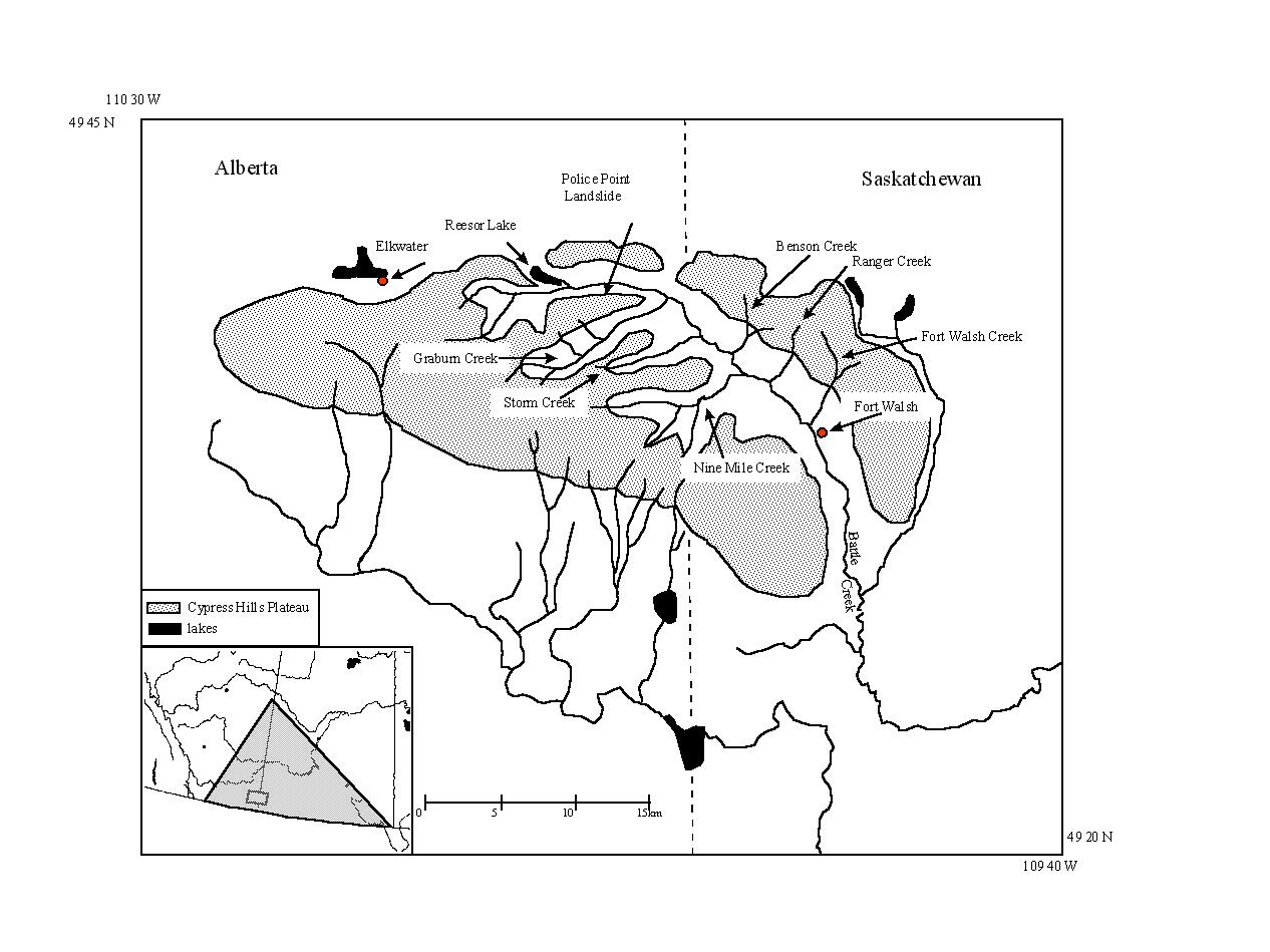
In the Cypress Hills of Alberta and Saskatchewan (Fig. 1), landsliding is a significant geomorphic process (Sauchyn, 1993; Sauchyn and Lemmen, 1996). Valley sides become prone to landsliding once Cretaceous clays are exposed by fluvial dissection. The processes of fluvial erosion, however, remain poorly investigated. The study attempts to evaluate the role of groundwater discharge in the fluvial erosion of valley heads in upper Battle Creek watershed, West Block of the Cypress Hills.
Groundwater discharge is of two types in the Cypress Hills: topographic and contact. Topographic discharge of shallow groundwater is caused by changes in topographic slope and characteristics of the surficial geology. Discharge along geologic contacts depends on stratigraphy. Where a highly permeable formation overlies a formation of significantly lower permeability, groundwater will follow the contact and discharge where the contact meets the topographic surface. This type of groundwater discharge is associated with landsliding. In this paper, however, the authors are concerned with the topographic discharge of shallow groundwater associated with runoff events. The hypothesis is that shallow groundwater discharge associated with saturation overland flow during rainfall - runoff events causes seepage erosion and sapping at valley heads in the Battle Creek basin.
Infiltration excess overland flow or Hortonian runoff (Pearce et al., 1986) is uncommon, because the infiltration capacity of most soil usually exceeds rainfall intensity. With the common conditions of permeable surfaces and low rainfall intensity, water infiltrates and flows via subsurface pathways. At the limit of subsurface water storage and transmission, gravity water is discharged to the surface to produce saturation overland flow (Dunne, 1990). The emerging groundwater erodes by seepage erosion and sapping (Higgins, 1984; Dunne, 1990; Moeyersons, 1991). Shear stress on the margins of pores entrains soil particles. This seepage erosion causes sapping when overlying soil collapses to creating gullies (Baker, 1990).
The hydrology and geomorphology of valley heads were studied for evidence of the character of storm runoff and erosion. Slow and moderate changes in stream flow and dissolved solids are indicative of a groundwater storm flow in small basins. The best morphological evidence of seepage erosion and sapping are discontinuous gullies emanating at valley heads (Higgins, 1984; Dunne, 1990; Moeyersons, 1991).. If groundwater is a significant agent of erosion, as we hypothesize, then the mapping of springs has geomorphologic importance. Therefore, a steady state model was applied, within a geographic information system (GIS), to predict the locations of both contact and topographic springs in Battle Creek basin.
STUDY AREA
The Cypress Hills are a remnant of late Tertiary erosion that lowered the bedrock surface of the northern Great Plains to its present level (Russell and Wickenden, 1933). The West Block is the highest of a series of dissected plateaux. It rises about 600 m above the surrounding plains (Figure 2). This relief prevented Wisconsinan glaciation of a 300 km2 nunatak (Stalker, 1965). Drainage of glacial meltwater through the West Block created major valleys and caused tributary streams to degrade to a lower base level.
The lower slopes of the Cypress Hills are underlain by Upper Cretaceous sediments (Table 1). The Bearpaw formation is dominated by marine shales and soft bentonitic sandy beds (Furnival, 1946). The Eastend, Whitemud, Battle and Frenchman formations are mostly sandstone but also contain shale, clay, bentonite and ironstone. The overlying Tertiary sediments are the Ravenscrag formation, thinly bedded sandstones with numerous beds of lignite and bentonite, and the Cypress Hills formation of sands, gravels and conglomerate (Leckie and Cheel, 1989). Almost all valley slopes have been subject to landsliding. Failure of bentonitic clay in the Ravenscrag, Frenchman and Battle formations is the likely cause of landsliding during periods of excess groundwater, high pore water pressure and, in turn, low shear strength in the clay beds (Sauchyn and Nelson, this volume).
The climate of the Cypress Hills is subhumid and cool. Mean annual temperature and precipitation are 2.5 °C and 457 mm (Cowell, 1982). Approximately 70% of the annual precipitation occurs in May and June. Local climates can varies considerably between the forested slopes of the valleys and the open grassland plateaux.
METHODS
GIS Modeling
For the tributary Benson, Graburn and Fort Walsh creeks, slope, surficial geology, streams and contours were overlaid in an ARC/INFO GIS. Using a form of O’Loughlin’s (1986) flow model, topographic discharge of groundwater is predicted to occur where Aq/b>KM. A is the area of the map unit, M is slope, b is the contour interval (5 metres), and K is the hydraulic conductivity of the surficial geologic unit. The product of A, M and K is q.
Where a highly permeable geologic formation overlies sediments with significantly lower permeability, groundwater will flow along the contact and discharge at the topographic surface. The degree to which the direction of flow is altered and in turn the possibility of a contact spring depends on the magnitude of difference between the conductivities of the two formations (Freeze and Cherry, 1979). Where the difference is greater than 100x, the contact between the formations was defined as a potential area for contact springs.
This method only predicts the distribution of springs. The parameters in the model reflect the probability of groundwater transmission based on geology, soils and topography. Mapping of the magnitude of groundwater discharge would require the evaluation of hydroclimatic parameters, and at least a seasonal temporal component to the model.
Field Mapping of Springs
Field mapping was conducted to locate and characterize groundwater discharge, and test the GIS results. Springs were characterized by surface expression and water chemistry to differentiate between the two discharge agents: geologic contact or local topography. There are four distinct surface expressions: lobate, marshy and gully and rocky. Lobate springs are located on valley sides. A phreatophyte covered lobe of regolith overhangs the discharge point. The lobe represents slow surficial mass wasting. The marshy expression reflects local morphology which causes dispersed discharge. Gullies from by seepage erosion and sapping. Rocky springs have a gully morphology and boulder deposits where spring where water has washed away fine sediment leaving the larger clasts.
Where spring flow was sufficient, it was sampled for the analysis of sulphate. The concentration of sulphate varies distinctly with subsurface residence time (Freeze and Cherry, 1979) and geologic source in the Battle Creek basin (McKay, et al., 1936). It increases with movement of the groundwater from the plateaux down through the underlying shales and silts (Rutherford, 1967; McKay et al., 1936). Therefore, sulphate concentration was used to distinguish between shallow groundwater, where topographic gradients tend to control spring discharge, and discharge of deep groundwater along geologic contacts.
Spring water was filtered through a 63 mm mesh to remove sediment. A turbimetric method was used to determine the concentration of sulphate. Barium chloride added to the sample precipitates with the sulphate ion to form barium sulphate. Light absorbency of the barium sulphate in suspension is measured with a photometer (HACH Drel 5 field kit) and the sulphate concentration determined by reading a standard curve. Accuracy of this method is expected to be within 10%.
Hydrological Investigation
The hydrology and water chemistry of first-order a stream, in a 1 km2 valley in the Fort Walsh Creek basin, was monitored to determine the role of groundwater during a storm event. The stream was instrumented with a V-notch weir (Figure 3) which channeled streamflow into a bucket where flow could be measured volumetrically. Rainfall was measured at two sites unobstructed by trees. The hillslopes were observed throughout the runoff event for either saturation overland flow or Hortonian runoff. Infiltration was measured a few hours after rainfall began to determine the infiltration capacity of the soils during storms.
Conductivity of rain and stream water samples was at two hour intervals using a conductivity probe from a HACH Drel 5 field kit. According to the manufacturer, accuracy is expected to be within 1%. As a function of the dissolved ions, the specific conductivity of rain water is usually very much lower than stream baseflow derived from groundwater. Therefore, conductivity indicates the source of the stormflow.
Morphometric Analysis of Valley Heads
The geomorphology of first order valley heads was examined for features characteristic of valley heads created by seepage erosion and sapping, in particular, discontinuous gullies (Patton and Schumm, 1975). Three valley heads were surveyed using a 50 m tape measure, Abney level and stadia rods.
RESULTS
GIS Modeling
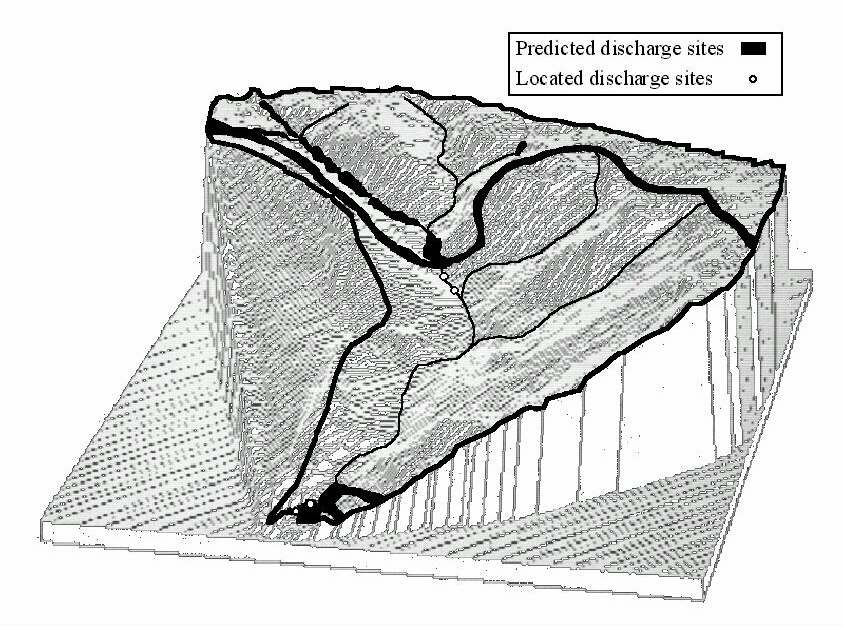
Results for Benson Creek are shown in Figure 4. Groundwater discharge is predicted to occur at the mouth of the basin, at the tributary valley bottoms with decreased topographic slope (concavity) and hydraulic conductivity, and along the contact between the Cypress Hills and Ravenscrag formations and the Eastend and Bearpaw formations. Four springs were found in the Benson Creek basin, two downstream of the predicted locations high in the basin and two within the predicted locations near the mouth. These results suggest the modeling was marginally successful in predicting discharge locations.
Field Mapping of Springs
Table 2 shows the results of the field mapping. Of the 120 springs found, the 23 springs listed are those sampled with sufficient flow for water sampling. The springs are grouped by surface expression with data on source, sulphate concentration, discharge agent and watershed. Cases of no or low sulphate (<10 mg/l) imply shallow, short residence time and, in turn, discharge in response to local topographic gradient. Of the 18 springs with no to low sulphate, 14 are at higher elevations in first and second order valleys. The four concentrations above 15 mg/L correspond to the only sixth and seventh order valleys in the sample. Thus, as expected, sulphate concentration reflects the subsurface residence time of groundwater in Battle Creek basin. As only half which Sulphate concentration is not related to discharge agent as an equal number of samples, with no to low sulphate, were from contact and topographic springs.
Hydrological Investigations
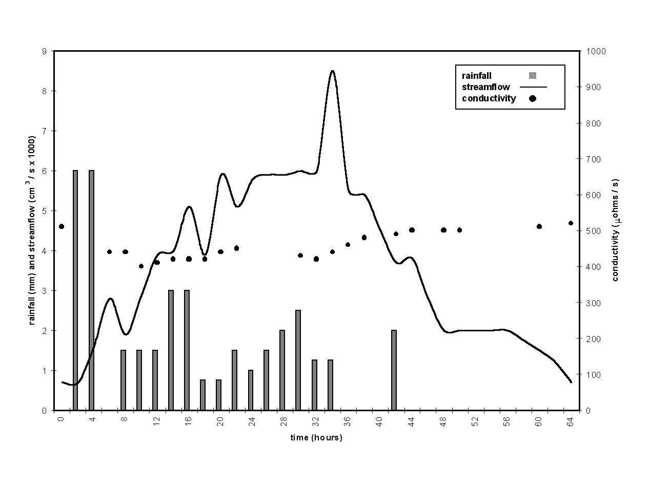
Figure 5 presents data from a storm and subsequent runoff at a first order valley head in the Fort Walsh Creek basin. Precipitation totaled 38.5 mm from 2:30 am July 9, 1992 to 7:30 p.m. July 10, 1992. Antecedent rainfall was 70 mm in the previous week, but no significant increase in flow had been observed at the valley head. The rainfall peak, comprising 30% of the total rainfall, occurred within the first four hours of the storm. Rainfall intensity was highest during this period, at 6 mm/hr. Thirty four hours later, stream discharge peaked at 8500 cm3/s, 7750 cm3/s above baseflow. As of rain fell In the first hour of the storm, rainfall was 6 mm or 8% of the weekly total, and streamflow more than doubled from 700 cm3/s to 1600 cm3/s. After another 6 mm of rainfall, flows doubled again to 2,800 cm3/s. Conductivity of the stream water decreased from 510 mohms/cm to a minimum of 400 mohms/cm and increased after the runoff event to 520 mohms/cm. The conductivity at peak flow was 440 mohms/cm. The conductivity of the rain water averaged 7 mohms/cm.
These data from one storm imply that saturation overland flow dominates the runoff process at valley heads. The 34 hour lag time for a 1 km2 basin is a strong indication that exfiltrating groundwater is the major contributor to stormflow (Newbury et al., 1969; Sklash et al., 1975). The disproportionate increases in flow to rainfall during the first few hours of the storm also suggest contributions from a source other than rainfall, that is, antecedent water. No Hortonian runoff was observed during the runoff event. The best evidence, however, that saturation overland flow dominates the storm hydrograph, is the relatively constant conductivity of stream water throughout the runoff event. The conductivity at peak flow (440 mohms/cm) suggests that pre-event water dominated stormflow at the headwater stream. The steady rise in conductivity during recession (Figure 5) also supports this conclusion.
Morphometric Analysis of Valley Heads
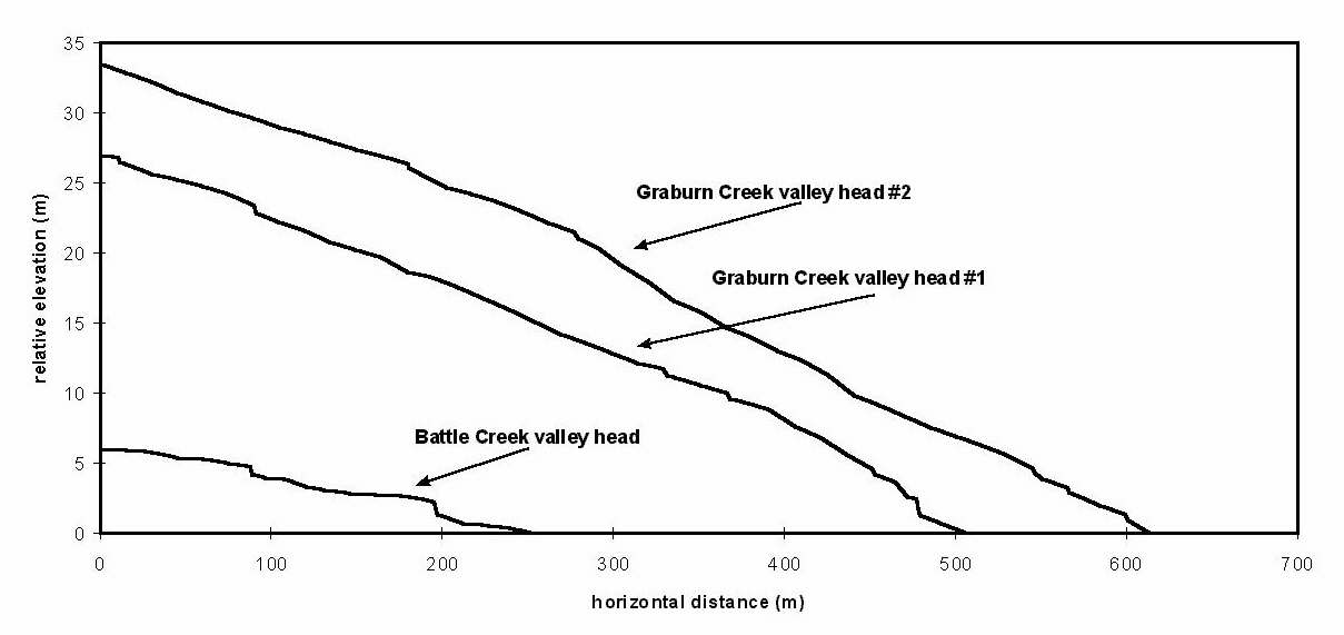
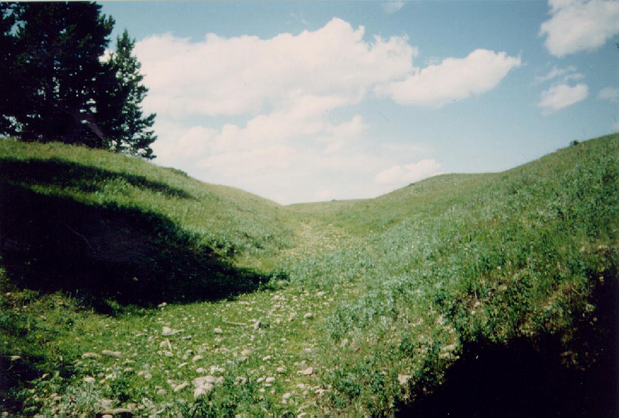
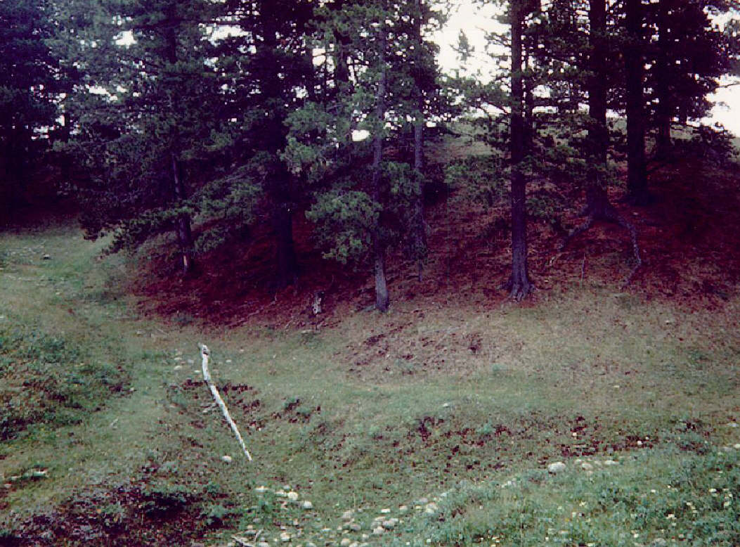
With the evidence for saturation overland flow, the valley heads should have the morphology characteristic of seepage erosion and sapping. Figure 6 is the longitudinal profiles of three first order valley heads. Discontinuous gullies are evident as indentations along the longitudinal profiles. Thus there is positive evidence of seepage erosion and sapping, and negative evidence with the absence of rills characteristic of Hortonian flow. A typical first order valley is illustrated in Figure 7. The cobbly, vegetated soil has a high infiltration capacity, estimated at 6 cm/min from field tests. The accuracy of these tests is limited, giving results 2 - 10 times the actual capacity (Dunne and Leopold, 1978), but even 10% of the measured infiltration capacity (6 mm/min) is sufficient for most rainfall to infiltrate. This high infiltration capacity of the sands and gravels of the Cypress Hills formation prevents Hortonian flow. Figure 8 shows an example of gullying at a valley head. There are no rills above the gully, again suggesting that the gullies are created not by concentrated Hortonian flow, but by saturation overland flow, seepage erosion and sapping.
Whereas much evidence exists for groundwater discharge and erosion at the valley heads, at the basin scale, the fluvial origin of the tributary valleys is disguised by mass wasting. Soil creep and shallow slumping occurs on the slopes of deeper second order valleys (Figure 9). The fluvial morphology of valley heads ends abruptly at a critical threshold of valley depth, beyond which clay shales of the Ravenscrag formation are exposed below Tertiary sands and gravels and virtually all valley sides assume the morphology characteristic of landslides (Sauchyn and Goulden, 1988).
DISCUSSION
Investigations of valley head morphology and stormflow in upper Battle Creek basin demonstrate that storm runoff is dominated by groundwater in the form of saturation overland flow. Exfiltrating groundwater causes seepage erosion and sapping and, in turn, gullying (Higgins, 1984; Dunne, 1990; Moeyersons, 1991). Discontinuous gullies, representative of seepage erosion and sapping processes (Patton and Schumm, 1975), occur at the heads of first order valleys. In the apparent absence of Hortonian overland flow and associated rill development, seepage erosion and sapping are the primary mechanisms of valley headward growth. At the basin scale however, the geomorphological influence of seepage erosion and springs is masked by the more dominant process of mass wasting.
By predicting groundwater discharge, the GIS model also predicts those slopes most prone to gullying and instability. The model did not include a climatological component, however, so the volume of flow at predicted locations cannot be estimated. While the GIS modeling and field mapping suggest the distribution of seepage erosion, sapping and landsliding, climate and the water table elevation are the key parameters that should be monitored to model the rates of these processes in the Cypress Hills. Monitoring of the groundwater table has been initiated as part of a study of the instability of Police Point Landslide (Sauchyn and Lemmen, 1996; Sauchyn and Nelson, this volume).
As the rate of gullying is related to the frequency of saturation overland flow, erosion at valley heads is strongly related to the antecedent moisture. With high infiltration capacities, the Cypress Hills formation requires a great deal of moisture to initiate saturation overland flow at the heads of low order valleys. In the case of the July 9, 1992 storm described above, 76 mm in a week was needed to initiate an increase in first-order streamflow. If the climate of the Cypress Hills becomes drier, low order valley heads will not likely have significant flow, thereby limiting any fluvial erosion. Saturation overland flow and, in turn, gullying, require saturation of soil to the surface. This threshold is more likely to be exceeded when the water table is near the surface, that is, with wetter climatic conditions.
ACKNOWLEDGMENTS
Funding for this research was provided by a Palliser Triangle Global Change Research Grant, the Saskatchewan Wheat Pool, Dr. Alice M. Goodfellow and Clifton Associates Ltd. The authors wish to thank Gregg Ambrosi, Iain Stewart, Kim Hodge, Troy Riche, Robert Stevenson and Cheryl Senft who assisted with fieldwork.
LITERATURE CITED
Baker, V.R. 1990: Spring sapping and valley network development; Groundwater Geomorphology, Higgins, C.G. and Coates, D.R. (eds.), Geological Society of America, p. 235 - 265.
Cowell, W. 1982: Cypress Hills Provincial Park climate, Alberta Recreation Parks and Wildlife, Edmonton, Alberta.
Dunne, T. 1990: Hydrology, mechanics, and geomorphic implications of erosion by subsurface flow; Groundwater Geomorphology, Higgins, C.G. and Coates, D.R. (eds.), Geological Society of America, p. 1 - 28.
Dunne, T. and Leopold, T.B. 1978: Water in environmental planning, W.H. Freeman and Company, New York.
Freeze, R.A. and Cherry, J.A. 1979: Groundwater, Prentice Hall, Englewood Cliffs.
Furnival, G.M. 1946: Cypress Lake Map Area - Saskatchewan, Canadian Geological Survey Memoir 242.
Goulden, M.R. and Sauchyn, D.J. 1986: Age of rotational landslides in the Cypress Hills, Alberta - Saskatchewan; Geographie Physique et Quaternaire, v.40, p. 239 - 248.
Higgins, C.G. 1984: Piping and sapping: development of landforms by groundwater outflow; Groundwater as a Geomorphic Agent, LaFleur, R.A. (ed.), Allen and Unwin, Boston, p. 18 - 58.
Leckie, D.A. and Cheel, R.J. 1989: The Cypress Hills Formation (Upper Eocene to Miocene): A semi-arid braidplain deposit resulting from intrusive uplift, Canadian Journal of Earth Sciences, V.26, p.1918 - 1931.
McKay, B.R., Beach, H.H. and Goodall, D.P. 1936: Groundwater Resources of the Rural Municipality of Cypress Hills #80, Saskatchewan, Geological Survey of Canada Water Supply Paper 224.
Moeyersons, J. 1991: Ravine formation on steep slopes: forward versus regressive erosion. Some case studies from Rwanda; Catena, V.18, p.309 - 324.
Newbury, R.W., Cherry, J.A. and Cox, R.A. 1969: Groundwater - streamflow systems in Wilson Creek Experimental Watershed, Manitoba; Canadian Journal of Earth Sciences, v.6, p.613 - 623.
O’Loughlin, E.M. 1986: Prediction of surface saturation zones in natural catchments by topographic analysis; Water Resources Research, V.22, p. 794 - 804.
Patton, P.C. and Schumm, S.A. 1975: Gully erosion, northwestern Colorado: a threshold phenomena; Geology, v.3, p.88 - 90.
Pearce, A.J., Stewart, M.K. and Sklash, M.G. 1986: Storm Runoff Generation in Humid Headwater Catchments: 1. Where does the water come from?; Water Resources Research, V.22, p. 1263 - 1274.
Russell, L.S. and Wickenden, R.T.D. 1933: An upper Eocene vertabre fauna from Saskatchewan, Transactions of the Royal Society of Canada, Series 3, 27, p. 35 - 65.
Rutherford, A. 1967: Water Quality Survey of Saskatchewan Groundwaters, Saskatchewan Research Council Report C-66-1.
Sauchyn, D.J. 1993: Quaternary and late Tertiary landscape evolution in the western Cypress Hills; Quaternary and late Tertiary Landscapes of Southwestern Saskatchewan and Adjacent Areas, Sauchyn, D.J. (ed.), Canadian Plains Research Center, Regina, p. 46- 58.
Sauchyn, D.J. and Goulden, M.R. 1988: The role of landsliding in the evolution of the Cypress Hills; Regina Geographical Studies #5, Paul A. and Widdis, R. (eds.), Department of Geography, University of Regina, p.63 - 80.
Sauchyn, D.J. and Lemmen, D.S. 1996: Impacts of landsliding in the western Cypress Hills, Saskatchewan and Alberta; Current Research 1996-B, Geological Survey of Canada, p. 7-14.
Sklash, M.G., Stewart, M.K. and Pierce, A.J. 1986: Storm runoff generation in humid headwater catchments: 2. A case study of hillslope and low order stream response; Water Resources Research, v.22, p.1273 - 1287.
Stalker, A. 1965: Pleistocene ice surface, Cypress Hills area, Cypress Hills plateau Alberta and Saskatchewan, Weihmann, I. (ed.), Alberta Soceity of Petroleum Geologists 15th Annual Field Conference Guidebook, Part 1, Cypress Hills plateau, p. 116 - 130.
Table 1: Bedrock Geology, Cypress Hills (Furnival, 1946; Freeze and Cherry, 1979; Menely, 1983; Weeks and Gutentag , 1988; Lennox , 1988; Leckie and Cheel, 1989)
| Epoch | Formation | Thickness (m) | Hydraulic Conductivity (m/day) |
| Oligocene | Cypress Hills | 15 - 76 | 100 |
| Paleocene | Ravenscrag | 70 + | 10-4 |
| Upper Cretaceous | Frenchman | 3 - 45 + | 10-1 |
| Upper Cretaceous | Battle | 6 - 9 | 10-1 |
| Upper Cretaceous | Whitemud | 10 - 14 | 10-1 |
| Upper Cretaceous | Eastend | 21 - 37 | 10-1 |
| Upper Cretaceous | Bearpaw | 285 - 305 | 10-5 |
Table 2: Summary of spring characteristics
| Valley order | Sulphate (mg/l) | Formation of Origin | Surface expression | Discharge agent | Sub Basin |
| second | 0.0 | Ravenscrag | gully | topographic | Fort Walsh |
| first | 0.0 | Cypress Hills | gully | topographic | Battle |
| third | 0.0 | Ravenscrag | gully | topographic | Benson |
| second | 2 | Whitemud | gully | topographic | Fort Walsh |
| second | 6.0 | Cypress Hills | gully | topographic | Battle |
| third | 8.0 | Ravenscrag | gully | lens contact | Benson |
| second | 9.6 | Cypress Hills | gully | lens contact | Graburn |
| sixth | 16.5 | Whitemud | gully | topographic | Nine Mile |
| first | 0.0 | Cypress Hills | rocky | topographic | Battle |
| second | 5.8 | Cypress Hills | rocky | lens contact | Storm |
| second | 7.0 | Cypress Hills | lobate | lens contact | Graburn |
| second | 7.0 | Cypress Hills | lobate | lens contact | Battle |
| second | 7.0 | Cypress Hills | lobate | lens contact | Battle |
| second | 12 | Cypress Hills | lobate | lens contact | Graburn |
| second | 0.0 | Cypress Hills | marsh | topographic | Graburn |
| second | 0.0 | Ravenscrag | marsh | topographic | Ranger |
| second | 1.0 | Ravenscrag | marsh | topographic | Fort Walsh |
| second | 2 | Whitemud | marsh | topographic | Fort Walsh |
| third | 6.4 | Whitemud | marsh | topographic | Fort Walsh |
| third | 8.5 | Ravenscrag | marsh | lens contact | Ranger |
| sixth | 15.7 | Ravenscrag | marsh | lens contact | Nine Mile |
| seventh | 22.5 | Whitemud | marsh | lens contact | Battle |
| seventh | 50.0 | Bearpaw | marsh | topographic | Battle |
Figure 1: Location of the Cypress Hills and Battle Creek in southeastern Alberta and southwestern Saskatchewan.
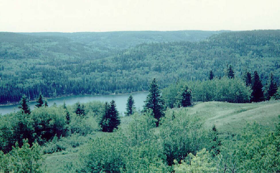
Figure 2: The dissected plateaux of the Cypress Hills with Reesor Lake in the middle and Battle Creek valley beyond the spur in the middle of the photo.
Figure 3: V-notch weir on the first order tributary of Fort Walsh Creek. The Tilley hat in the middle left part of the photo is used for scale.
Figure 4: Results of the GIS modeling of groundwater discharge sites - Benson Creek
Figure 5: Fort Walsh Creek storm hydrograph - July 9th and 10th, 1992
Figure 6: Longitudinal profiles of valley heads. The notches along the profiles represent the heads of discontinuous gullies.
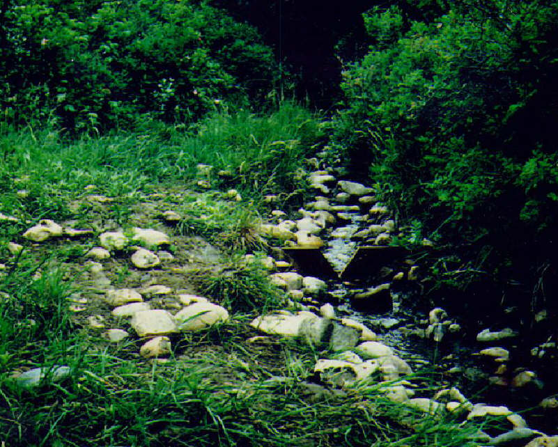
Figure 7: A typical first order valley. The cobbles and gravels are visible in the lower left portion of the photo.
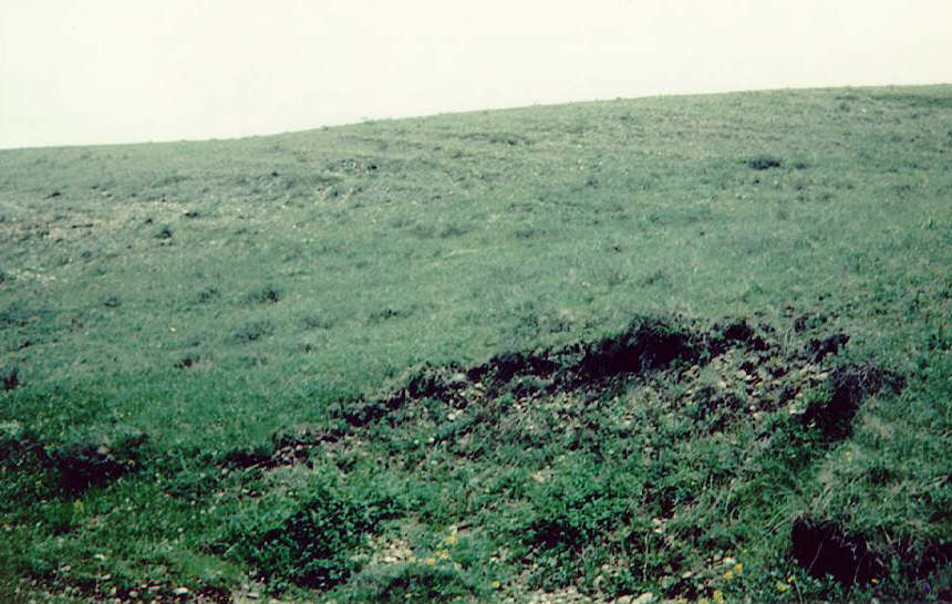
Figure 8: Gullying at the confluence of two first order valley heads. The concentration of subsurface flowpaths at the mouth of the valleys causes groundwater flows to exceed soil transmissivity, leading to exfiltration and the creation of he gullies.
Figure 9: Second order valley showing terracettes on the hillslopes, indicating soil creep.