Geography 411 - Field Techniques
Topographic Surveying
Topographic Surveying
Use of topographic surveying in geography:
General Principles
select a scale in advance; this determines the plotable error
work from the most accurate to the least accurate methods
orient each survey, preferably with respect to true north
the first stage of surveying is always establishing horizontal and vertical control: the distance, direction and difference in elevation between key fixed points
establish a survey plan that includes checks on accuracy, e.g. redundant points, pacing of measured distances, surveying between fixed positions, etc.
Methods
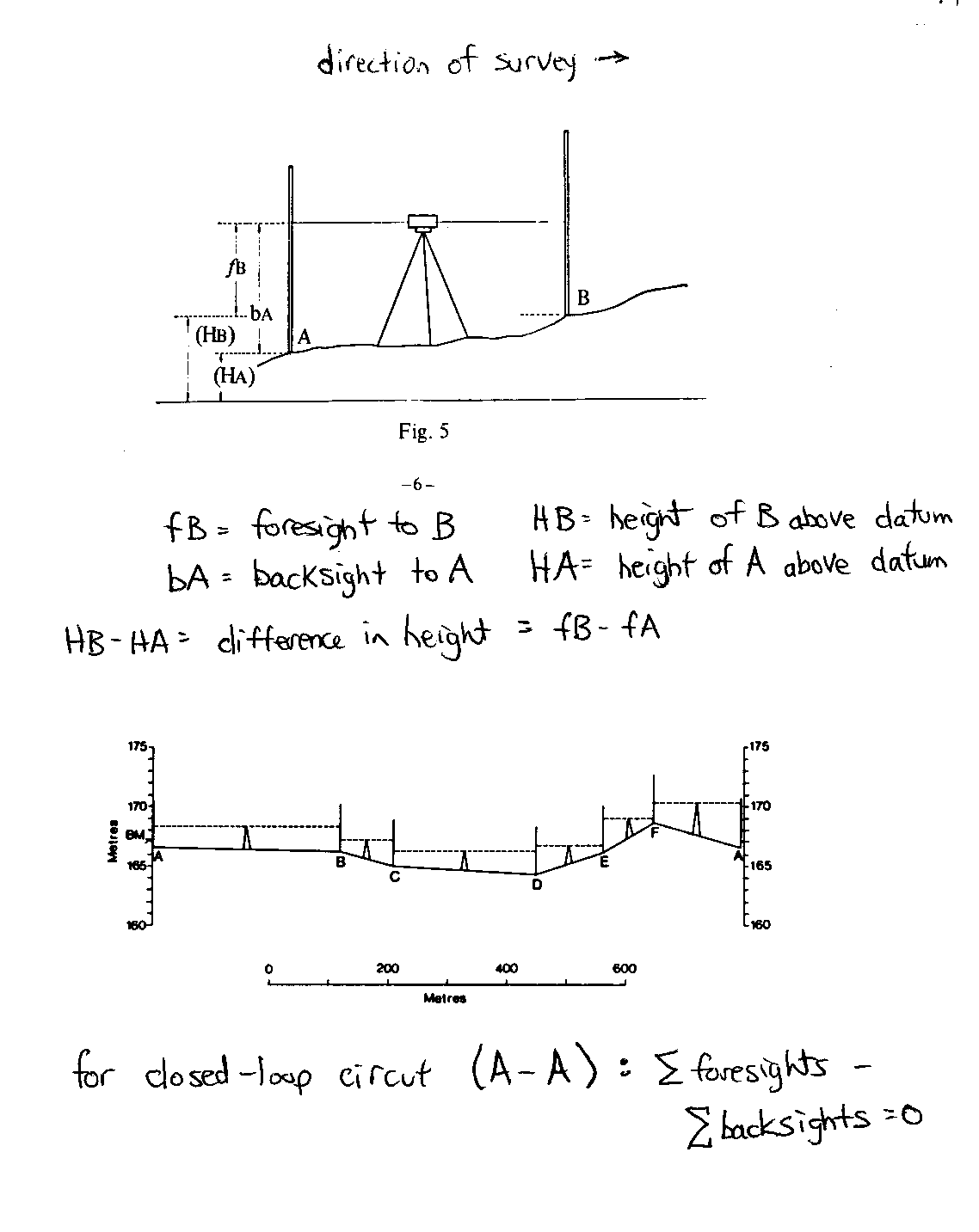
Leveling is
more accurate since elevation differences are measured not calculated. Two readings are
taken at each position of the automatic level: a backsight towards a
station located before the level on the traverse and a foresight to the
next station on the traverse. Thus the stadia rod occupies two stations, before and after
the level on the survey. The difference in elevation between successive stations if
the difference between the backsight and the foresight read from the stadia rod. For
each position of the level, the lengths of the foresights and backsights should be
approximately the same since accuracy is a function of the distance of a sighting.
The level operator should anticipate the distance to the next station and set up the level
midway along this distance (note: the distance that can be sighted decreases with increase
in slope, since the stadia rod will disappear above or below the level line of
sight). The lengths of backsight and foresight can be paced by the rod person or
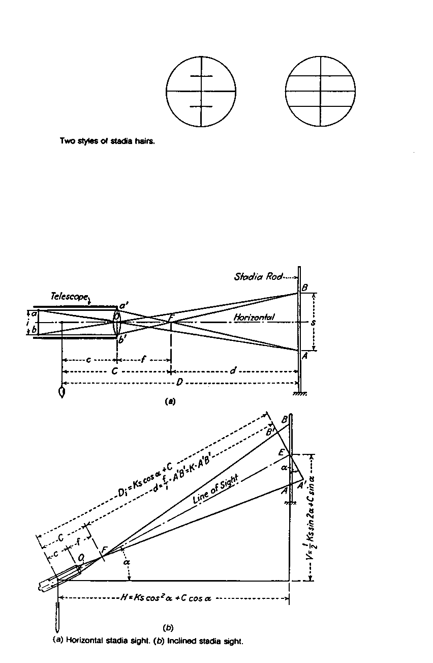
measured by the interval between the upper and lower cross hairs (tachymetry).
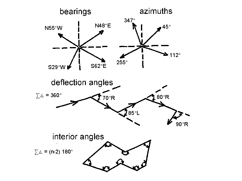
- horizontal angle measured with a compass
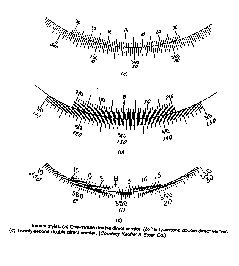
- precise measuring devices use vernier scales
- direction is expressed relative to a reference line or meridian
- true meridian: a north-south line
- magnetic meridian: a line parallel with the earth's magnetic lines of force
- assumed meridian: an arbitrary line
Types of Traverses
Shape Of The Earth And Error: The two basic problems in topographic surveying
The shape of the earth (the geoid) is a consideration only in geodetic surveying, where over long distances flat surfaces are not level, plumb lines are not parallel and the sum of the angles in a triangle is greater than 180o; thus precise surveys over large areas employ the principles of geodesy (the mathematical properties of an ellipsoid that emulates the earth); however with most surveys, including virtually all topographic surveying in geography, the departure of horizontal lines from level and plane angles from spherical angles are negligible and can be ignored
plane surveying: where the earth's surface is regarded as a plane; level lines are considered straight, angles are considered to be plane angles and plumb lines are considered to be parallel within the survey
with these assumptions, the relative locations of points can be calculated using the principles of plane trigonometry:
Error
Distances and angles can never be determined exactly; measurements are subject to error. Error can be controlled through procedure and instrumentation. Surveys are conducted according to standard levels of accuracy (first order, second order, etc.). The desired level of accuracy depends on the intended us of the survey data (e.g. locating permanent stations or surveying bridges and dams versus surveying for terrain analysis or orienteering).
For topographic mapping, the desired level accuracy is the plottable error, the shortest distance that can be depicted on a map at a given scale. The drafting of lines generally is accurate to within 0.25 mm. At 1:1000, 0.25 = 250 mm or 0.25 m on the ground. Optical measuring devices will provide this level of accuracy. At 1:25,000, 0.25 mm = 6.25 m on the ground. Pacing of distance will provide this level of accuracy, although in practise accuracy is greater than the plottable error by as much as one-third (e.g. 80 mm rather than 250 mm at a scale of 1:250,000) so that plotting and surveying errors are not compounded.
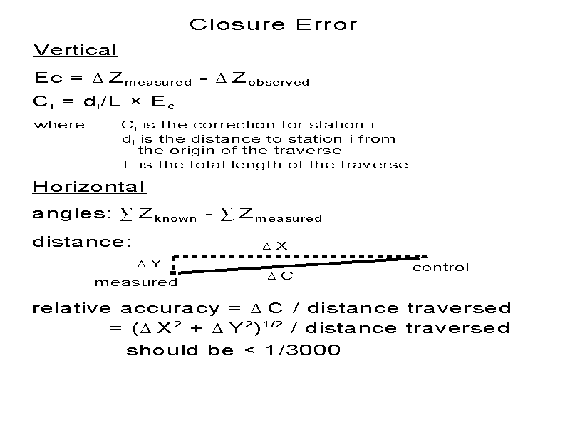
Adjusting For Closure Error
Horizontal angles
Difference in elevation
Closure error can be determined for closed and closed-loop traverses. The closure error can be divided by the number of stations on the traverse or the correction at each station can be calculated according to the distance from the origin of the survey:
Ci = di/L * Ec, where
This method accounts for the propagation of error with distance.
Horizontal distances
As with leveling, closure error can be determined for closed and closed-loop traverses, where the coordinates of the end points are identical or known. Location in the horizontal plane are given by x and y coordinates (e.g. northing and easting). Using the measured horizontal distances and adjusted angles, calculate the coordinates of each station. The difference between the calculated and known coordinates of the end control point is dx and dy, the closure error in x and y. As with leveling, the adjustment is a function of the distance traversed (Li) relative to the total length of the traverse (L):
Cdxi = dx * Li/L Cdyi = dy * Lii/L, where Cdxi and Cdyi are the adjustments in x and y coordinates at station i
The relative accuracy of distance measurements can be expressed as ((dx2 + dy2)1/2)/L. An angular error of one minute is equivalent to a distance measurement error of 3 cm over a distance of 100 m, since the sine of 1/60o is .00029.