Global Positioning Systems
Reference
Global
Positioning System Overview
Peter H. Dana
Department of Geography, University of Texas at Austin.
Introduction
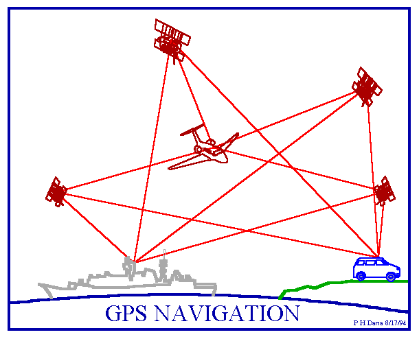
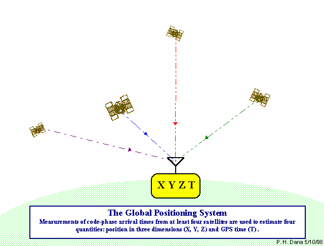
GPS is an artificial solar system
the consistent and predictable paths and position of stars and planets were measured with crude instrurments (sextants) and a book of tables (the ephemeris) to triangulate an unknown position on the earth
NAVSTAR (Navigation Satellite Timing and Ranging), the GPS developed by the US department of Defense (DoD)
reached initial operational capacity in December, 1993
has been fully operational since April 27, 1995
consists of three segments
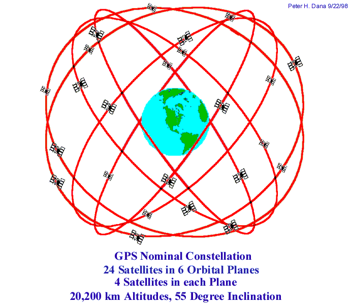
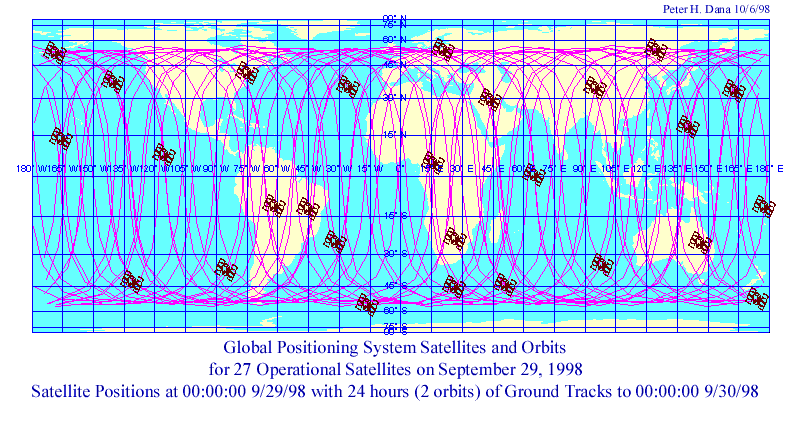
Space Segment: space vehicles (SVs)
24 operational satellites (spares as well) orbit the Earth every 12 hours (i.e., not geosynchronous) at 20,200 km
six orbital planes inclination of 55 degrees to the equator
satellites appear 4 minutes earlier each day
spacing of satellites such that 5 satellites will be available (in view) to users worldwide (with PDOPs < 7)
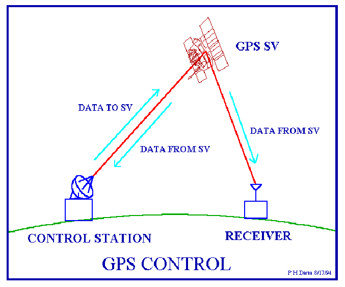
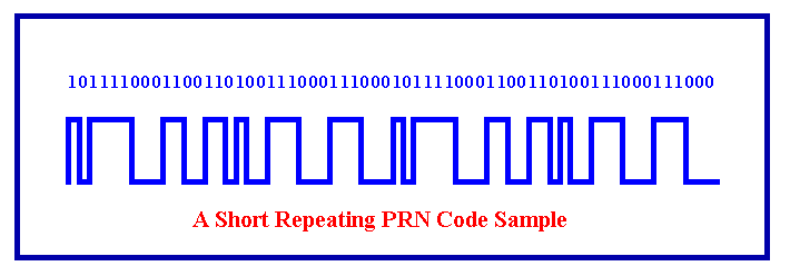
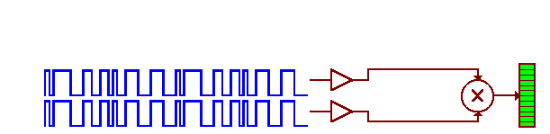
two components of radio message transmitted by the satellites; one for timing purposes (pseudo random code) and one for satellite positioning (ephemeris)
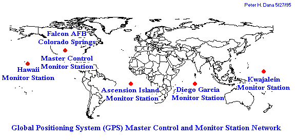
consists of four monitoring stations around the world close to the equator (Hawaii, Kwajalein, Ascension Island, Diego Garcia) and master control station in Colorado Springs
twice daily information is uploaded to the satellites relating to navigation and ephemeris
User Segment
- the users, including receivers, hardware, software, antennas, computers and data loggers
positioning, velocity and timing information
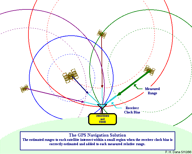
Satellite Ranging
Timing
GPS Positioning Services
Precise Positioning Service (PPS)
Authorized users (U.S. and Allied military, certain U.S. Government agencies, and selected civil users specifically approved by the U.S. Government) with specially equipped receivers use the Precise Positioning System
PPS Predictable Accuracy
Standard Positioning Service (SPS)
Civil users worldwide use the SPS without charge or restrictions. Most receivers are capable of receiving and using the SPS signal. The SPS accuracy is intentionally degraded by the DOD by the use of Selective Availability.
SPS Predictable Accuracy
GPS Satellite Signals
The SVs transmit two microwave carrier signals.
Three binary codes shift (modulate) the L1 and/or L2 carrier phase.
Selective Availability
Propagation Delays
Dilution of Precision - DOP
Ephemeris and Clock Error on Satellites
Receiver Error
Multipath
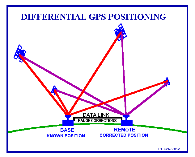
Differential GPS
Differential positioning is used to corrects bias at one location with measured bias errors at a known position. A reference receiver, or base station, computes corrections for each satellite signal. These corrections are passed to the remote, or rover, receiver which must be capable of applying these individual pseudo-range corrections to each SV used in the navigation solution. both receivers have to be using the same set of SVs. Differential corrections may be used in real-time or later, with post-processing techniques. Real-time corrections can be transmitted by radio link. Many public and private agencies (e.g., Geomatics Canada) record DGPS corrections for distribution by electronic means.
To remove Selective Availability (and other bias errors), differential corrections should be computed at the reference station and applied at the remote receiver at an update rate that is less than the correlation time of SA. Suggested DGPS update rates are usually less than twenty seconds. DGPS removes common-mode errors, those errors common to both the reference and remote receivers (not multipath or receiver noise). Errors are more often common when receivers are close together (less than 100 km). Differential position accuracies of 1 - 10 meters are possible with DGPS based on C/A code SPS signals.
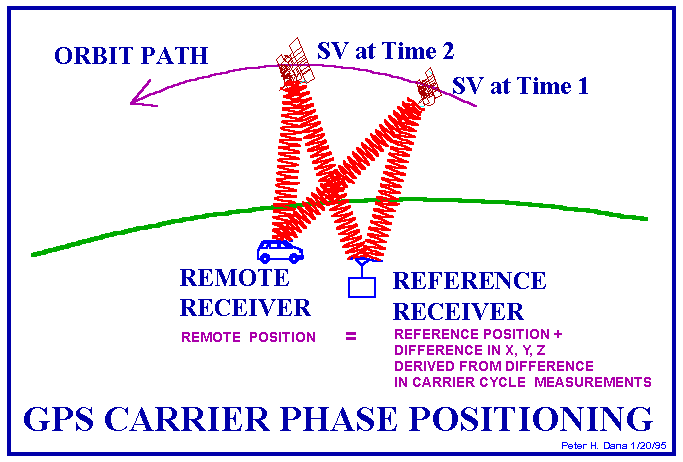
Carrier Phase Tracking (Surveying)
Carrier-phase tracking of GPS signals has resulted in a revolution in land surveying. All carrier-phase tracking is differential, requiring both a reference and remote receiver tracking carrier phases at the same time. In order to correctly estimate the number of carrier wavelengths at the reference and remote receivers, they must be close enough to insure that the ionospheric delay difference is less than a carrier wavelength. This usually means that carrier-phase GPS measurements must be taken with a remote and reference station within about 30 kilometers of each other. Special software is required to process carrier-phase differential measurements. Newer techniques such as Real-Time-Kinematic (RTK) processing allow for centimeter relative positioning with a moving remote receiver. This use of GPS requires specially equipped carrier tracking receivers.
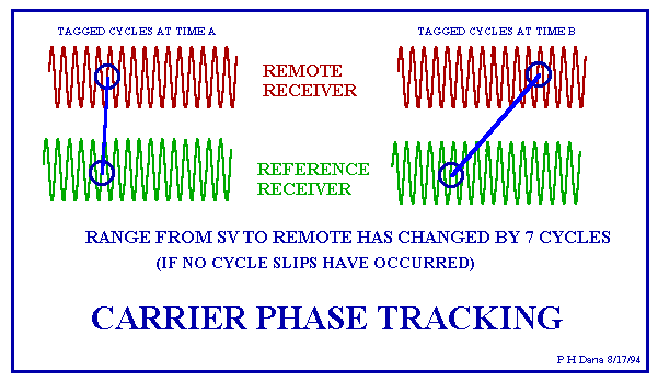
The L1 and/or L2 carrier signals are used in carrier phase surveying. If tracked and measured these carrier signals can provide ranging measurements with relative accuracies of millimeters under special circumstances. Tracking carrier phase signals provides no time of transmission information. The carrier signals, while modulated with time tagged binary codes, carry no time-tags that distinguish one cycle from another. The measuremerts used in carrier phase tracking are differences in carrier phase cycles and fractions of cycles over time. At least two receivers track carrier signals at the same time. Phase difference changes in the two receivers are reduced using software to differences in three position dimensions between the reference station and the remote receiver. Problems result from the difficulty of tracking carrier signals in noise or while the receiver moves.