Geography 327 Hydrology
Dimensions of Point Precipitation
Depth
- range = maximum – minimum for a given period and place
- standard deviation, the square root of the sum of the average squared deviations from the mean: (sum (pi-P)2/n-1)1/2, where pi is the individual precipitation observation, P is the mean precipitation and n is the number of observations
- interquartile range (dispersion about the median) between the 75% and 25% positions in a ranked series, i.e., between the upper and lower quartiles
- coefficient of variation: standard deviation / mean; low for humid environments, highest for dry climates
- inter-annual variation: sum | pi-1 – pi | / n-1 * 100; a measure of average variation among years expressed as a percentage; highest for direst climates (e.g., rebate on snow blower if snowfall is less than average by a certain amount, but then most people live in humid climates where the IAV is low)
Intensity
- soil erosion: raindrop impact, rainsplash and sheet erosion
- local flooding
- visibility
- snow removal
- nature of the hydrological cycle and thus landscape (bursts versus sustained input of similar annual amounts)
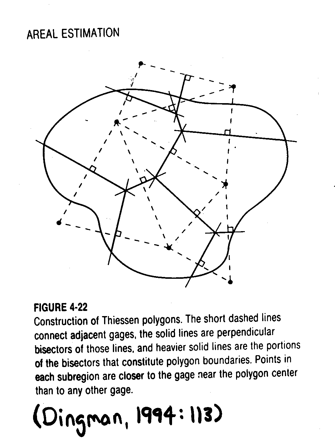
Areal extent
Temporal extent (duration)
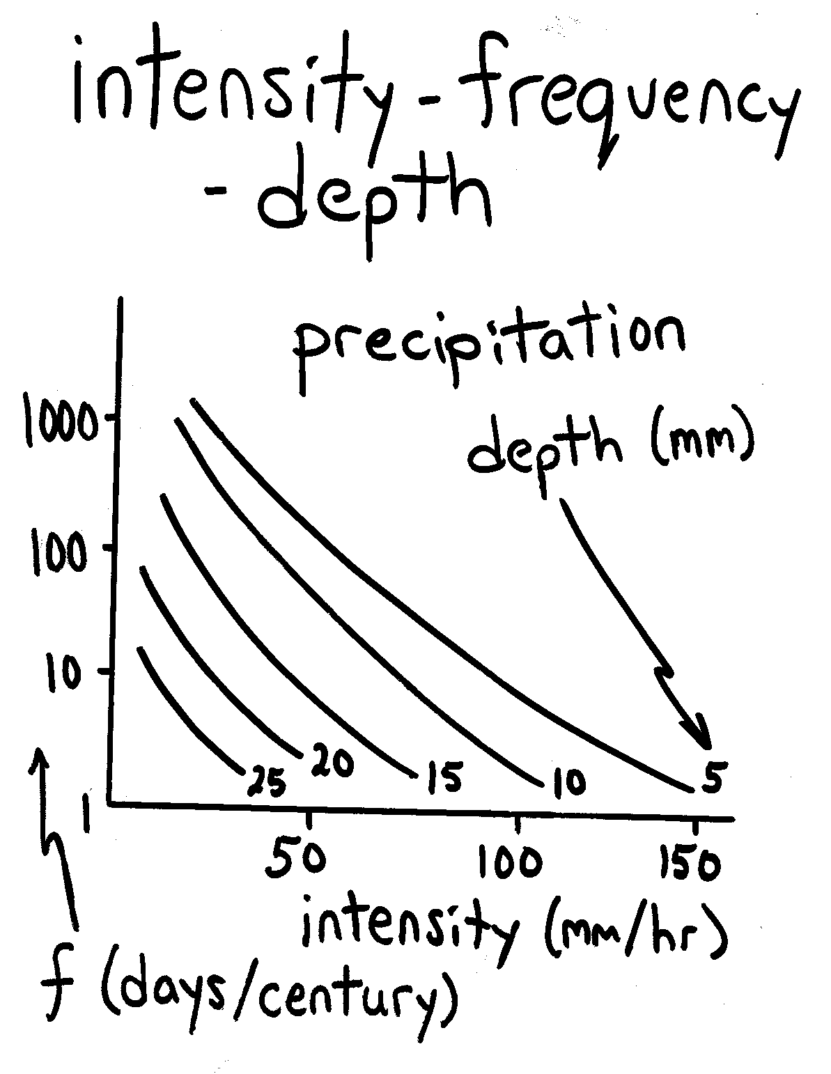
Frequency
- # of events of a specific magnitude / specific period of time (e.g., once in ten years)
- probability: # of events of a specific magnitude / total # of events (e.g., 3 events / 300 storms = 0.01; or 2 monthly totals > 50 cm out of 60 months = 0.033)
- recurrence interval (return period): average time period during which precipitation of a specific magnitude will reoccur (e.g., 100 year flood occurs on average once in 100 years)
- return period and probability are inversely related; i.e., there is a small probability of a storm with a long return period
- return period (years) = (n+1) / r, where n is the # of observations and r is the rank of a particular magnitude
- thus the highest precipitation event or total (r = 1), will occur only once during the period record (n) and thus will have a return period of n+1
- described by straight lines or shallow curves on semi-log scale (log – frequency)
- decrease in frequency with increasing intensity and depth
- existing records which are sufficiently large (although records can be too long by encompassing climate change: a moving mean)
- theoretical frequency distribution if a precipitation record can be assumed to approximate a known frequency distribution (e.g., log normal or Weibull)
- probabilities are extrapolated assuming that the distribution of storm size and intensity will remain the same (probably invalid with global warming)
- probabilities periodically be adjusted (e.g., after extreme events)
N.B.: probabilities indicate nothing about the timing of events!! (just long term probability); thus two hundred year storms could occur in consecutive years, but their long-term probability still remains 0.01
| Engineering Structure | Probability of storm that exceeds it's capacity |
| urban storm sewers, airports, expressways | 0.2 (5 year storm); inconvenience but small threat to life or property |
| protection of rural land (e.g., levees) | 0.1 (10 year storm); more severe consequences than above |
| protection of urban land | 0.4 (25-year) storm; more population than rural land |
| spillways (reservoir drainage) | |
|
0.04 < p < 0.01 (25-100 year storm) |
|
probable maximum precipitation* |
* PMP is the depth of precipitation for a given location and duration that can be reached but not exceeded under imperfectly known meteorological conditions
[ Course Outline | Next Topic ]